
 Volunteering
 Safety
 Wildlife
 Newsletter
Old Maps of Oakhurst Forest Preserve
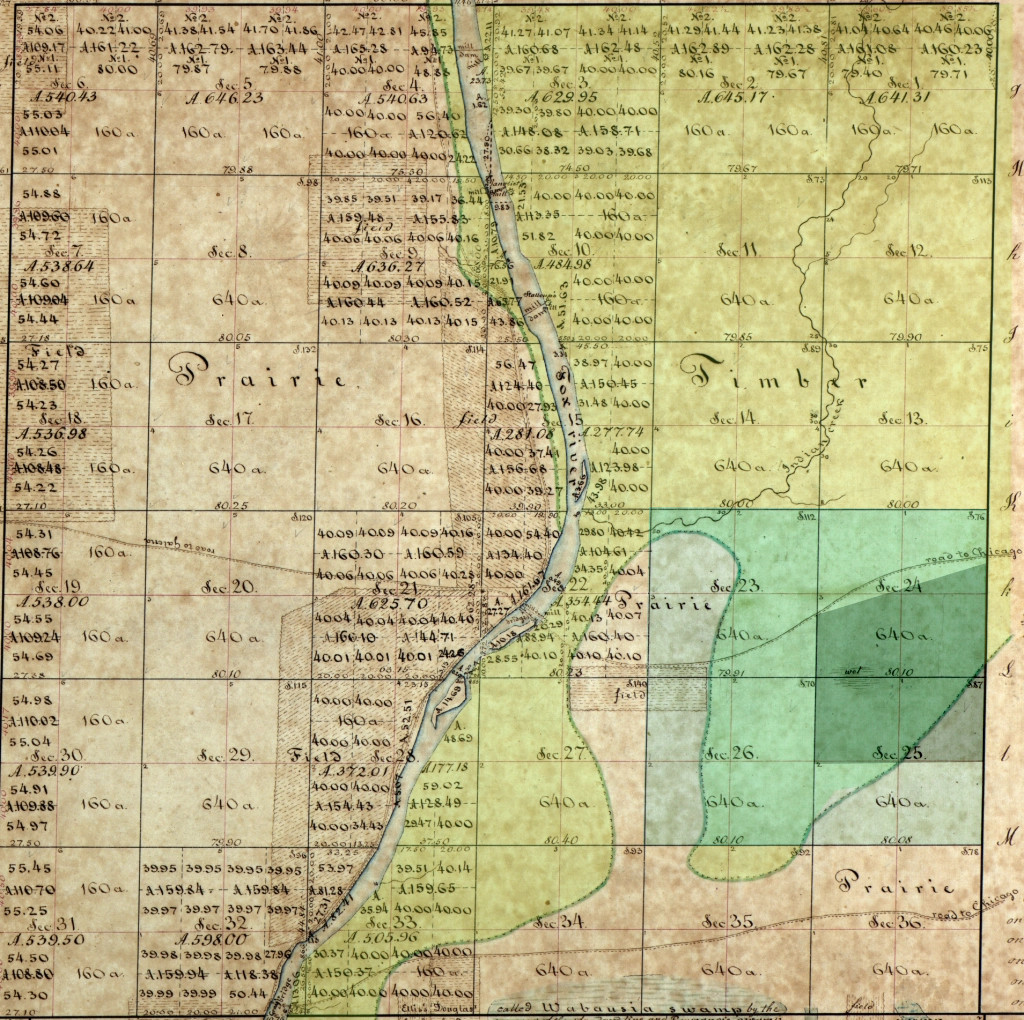
1838 Survey Map
This is the earliest map of Aurora township, back when Oakhurst was part of the Big Woods forest that stretched from Oswego to Batavia. I have highlighted 4 plats within Aurora township that will be the focus of subsequent maps. The darker green is the approximate border of present day Oakhurst. If you zoom into the map, you will notice part of the land that will one day be excavated to become Lake Patterson is labelled as "wet".
There are two roads to Chicago - one from Aurora (New York street) and one from Montgomery (Montgomery Rd). Most of the farmfield are west of the river, but there is a farmstead labelled Douglas on the map. No prize for those who know where there is today!
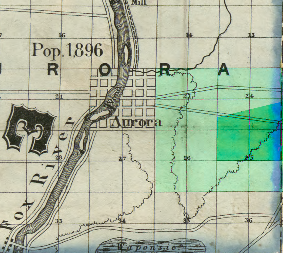
1851 Map
The next image is taken from a larger map that covers the Cook county region, so the roads to Chicago are probably a litte skewed. What fascinates me is the Wabansie Swamp shown on this map and the one previous, just south of Montgomery Road. Today, this swamp are farms field adjacent to Farm and Fleet and west of Hill Avenue, and just sohappens to be at the end of my street. Some years ago when rains brought a lot of flooding, the entire field became a swamp once again, which was surreal to look at. Last year I found some Great St John's Wort near the waubansee creek, which I like to think is a remnant species that dates back to the old swamp.
1860 Map
This is the earliest map of Aurora that provides details on the farm homesteads. Once again, the highlighted the area is Oakhurst. The far right edge is the border between Kane and DuPage county; the road at a diagonal is New York Avenue; the left border is Farnsworth Avenue, while the south border is 5th Avenue.
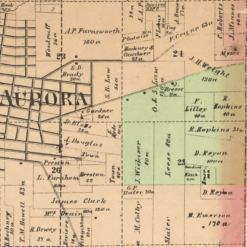
For shits and giggles, I googled the people mentioned in the map, and found a page that lists their gravesite, or my best guess of their identity. If you hover the mouse over a farmstead, a popup may occur with their full name and year of birth/death; a click will take you to the Find A Grave page.
Upon examining the map closer, you may notice the 160 acres belonging to Asa P. Farnsworth whose property borders Liberty Street to the south, Ohio St to the east, Dearborn Ave to the north, and of course, Farnsworth to the east.
Source: Map of Kane County, Illinois1871 Map
The next map is eleven years later, but this conveniently displays the wooded areas. Here we can see that the eastern properties containing the original Oakhurst woodland belong to David, Ferry and Regan. Several of the farms have changed hands since 1860, but Jacob Wickizer, a honest man if there ever was one, still owns the property along Farnsworth, and Lies the adjoining lot; I am assuming 'Leese' was an anglicization of the name of Lies.
I had to put on my sleuthing hat to figure out who George Loucks was. The nearby property is most likely Jesse Loucks, his father, who moved from New York, and died in Aurora. George and wife would have five brats of their own, first three born in New York, and the last two in Aurora. This places them in Aurora between 1861-69, before moving on to Iowa and Washington State. Part of the land would then go to A.Loucks; this could be one of his two brothers, Alonzo or Almerin, both of whom are buried in the area. I tagged the plot to Almerin, since he had the decency to share a photo online.
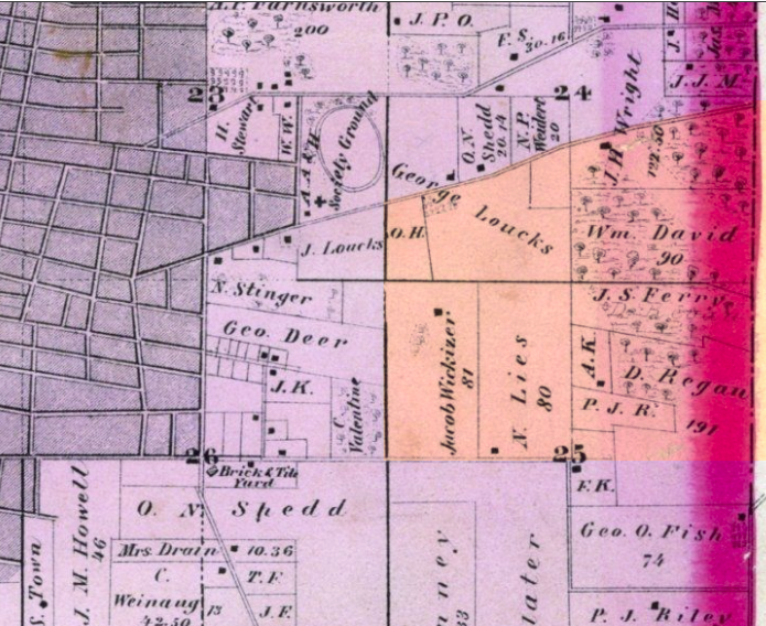
1892 Map
Now we move forward 21 years, and Aurora has continues to grow and develop. Most of the Farnsworth property has been swallowed up by Aurora, and what remains has been passed down to his daughter, Jessie Estella. Farnworth Ave is now clearly marked, and 5th Avenue has been extended east. The unknown OH property is now a subdivison of the city. The initials JPO on the previous map are now identified as J.P.Oberwise, mostly likely the immigrant from Germany whose grandson would found the Oberweis Dairy. Mr Shedd's soap factory is also marked on the map.
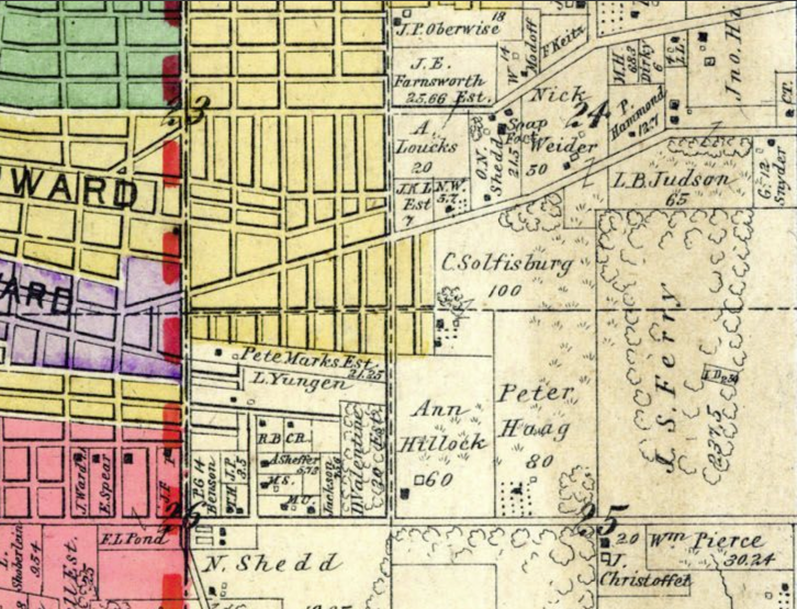
As far as Oakhurst is concerned, Ferry now owns the entire woodland, which still appears to be continuous. Jacob Wickizer has sadly passed, and the property is now in the hands of James and Ann Hillock; in seven years, both husband and wife would die under mysterious circumstances, suspected alcohol poisoning, although the son refuted the claim they were alcoholics. Peter Haag now has the Lies property.
Solfisburg now owns 100 acres. I am assuming this is Christian, the immigrant born in Switzerland. The name may be familiar to some as there is both avenue and park in Aurora bearing the name, and his grandson Roy would become a Chief Justice of Illinois.
This map also shows other isololated woodlands - two in the Solfisburg property, one at New York and the other at the end of Grand Blvd, roughly where MLK Park is today. A third woods is in Haag property at 5th Avenue, which is around where the community gardens are. Once again, a wetland is clear visible on the map where the lake will be.
1939 Aerial Photo
We now fast forward 43 years when we have the first ever aerial photographs of the county. I took the bondaries of the 1892 map, and superimposed them on the photograph - this way you can see how the canopies line up. I am not sure how accurate my borders are, but I made adjustment in order to get the areas roughly matching.
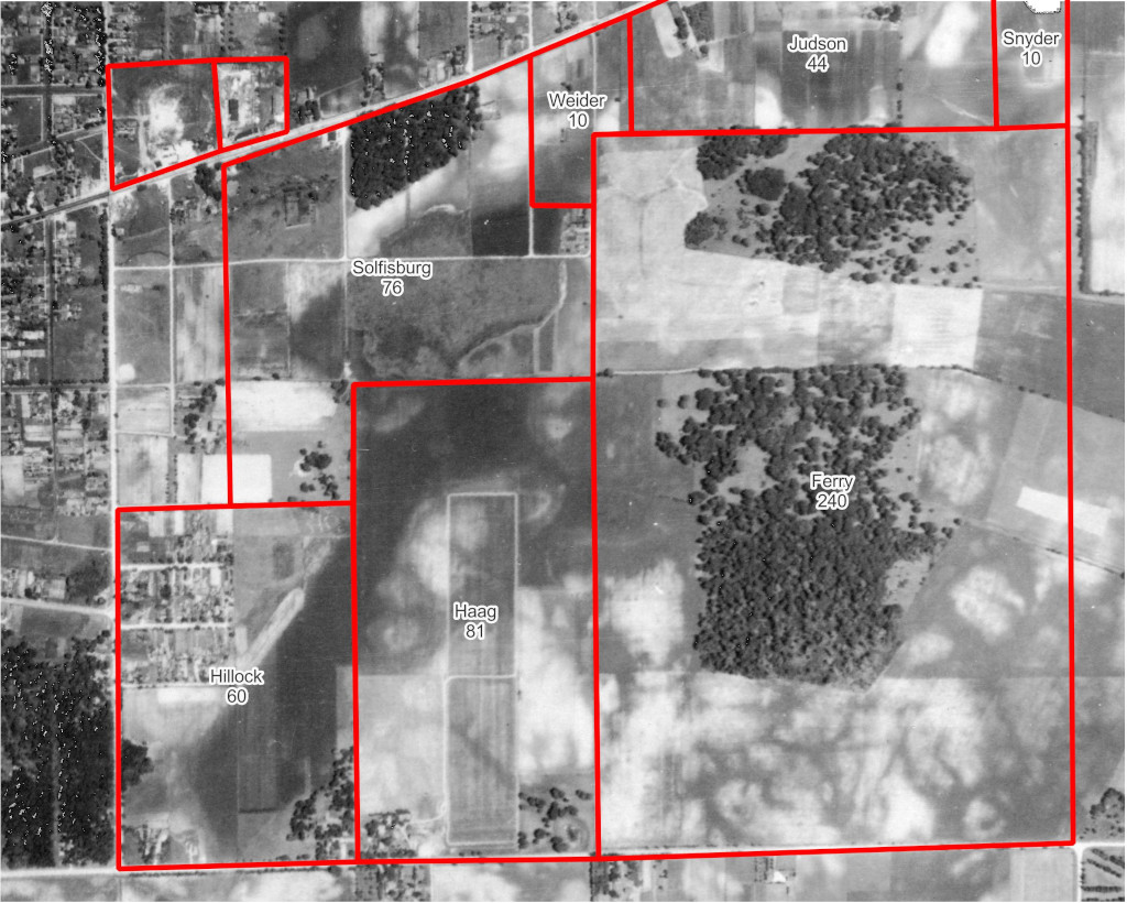
A few things jump out on ths map. First is the field that dissects the woods into two sections, a feature that still is noticable today. Second is the dark shading of the land that will become the lake, indicating the area is stil wetter than the land around. The corner of the former Hillock property is wooded, and white oaks can be found here today.
2023 Sateliite Photos
Last but not least, we skip to the present day to witnesswhat has changed in the intervening 80 years. Obviously the big difference is the presence of the man-made lake, and its hilly by-product.